Champlain Area Trails (CATS) are mostly in the central Champlain Valley towns of Essex, Westport, and Willsboro. We continually expand the trail network and will eventually connect to other Champlain Valley communities and to trails in surrounding areas (the Adirondack Mountains, Clinton County, Quebec, Vermont, and the Hudson Valley).
You can find quick descriptions of the trails below. For maps, continue scrolling down to the section named "Attachments" where you can find maps of the whole trail network, individual trails, and clusters of trails. There are some trails we have yet to map--so check back as we continually update this page. Please let us know your suggestions for improving the descriptions and maps.
We encourage you to help create and maintain trails by participating in our trail projects--the trail projects are fun and rewarding--just click on the "Events" tab to read about our upcoming trail projects and hikes. We send out email notices for upcoming projects--to be included on our email list please click on the "Contact" tab.
We invite you to become a "trail adopter"; Yes, you, your friends, and family can take responsibility for keeping a trail attractive and safe for the people who will hike there. To become a trail adopter, just reply on the "contact" tab.
We hope you enjoy the Champlain Area Trails.
Note: We are still writing descriptions for some of the trails - if you want to write a description please an email to champlaintrails@gmail.com.
*** MAPS for the trails are below so scroll down to "Attachments."
| Trail Name | Nearest Town | Length | Rating | Type | |
| Beaver Flow Trail | Essex & Westport | 2.25 miles (each way) | Mild | There & back or loop via Homestead Trail & Cook Rd. | |
| Big Woods Trail | Willsboro | 2 mile | Mild | Several loops; river section tends to be overgrown in summer | |
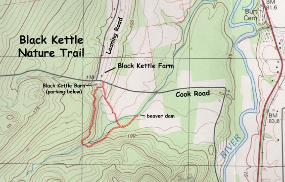
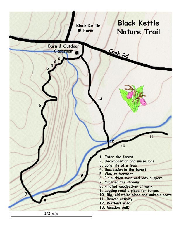
| Black Kettle Nature Trail | Essex | 1.5 miles | Mild | Loop; has nice overlook | |
| Bobcat Trail | Westport | 1 mile (each way) | Mild | There & back | |
| Boquet Mountain Trail | Essex | 3 miles (each way) | Mild | There and back with side trails | |
| Coon Mountain Trails | Westport | 1 mile (each way) | Moderate | There & back to great view; Hidden Valley Trail loops into main trail | |
| Homestead Trail | Essex | 2.5 mile | Mild | Loop via Beaver Flow Trail and Cook Road | |
| Lee Park Trail | Westport | 1/2 mile | Mild | Loop | |
| McAullife Road Trail | Essex & Willsboro | 2 mile (each way) | Mild | There & back | |
| Noblewood Trails | Willsboro | 1 mile (each way) | Mild | There, back & loops | |
| Rocky Ledges Trail | Essex | 3 miles | Mild | CLOSED during hunting season Sept 15 - Dec 15 | |
| Split Rock Trails | Westport & Essex | many miles of trails | Mild | Loops to Lake Champlain & overlooks | |
| Wildway Overlook Trail | Essex | 1 mile (each way) | Mild | There & back to great view; easier hike than Coon Mtn Trail |

